 In the early 1970s, we had friends who lived in a rambling old brick house about a mile from the river west of Rice, Minnesota. The house was built as a hotel by George T. Rice, catering to travelers on the Red River Oxcart trail and later to stagecoach travelers along the same trail/road. This map shows the area in 1874, and the relatively straight road between the river and the tracks must have been that trail. Wow.
The inn and the stables behind it, by the 1970s, were in bad repair. They really weren't appreciated as historic, more as an eyesore. The whole place is gone now, except for the lilac bushes and daylilies.
Still, the idea that people stopped there on the way to and from Winnipeg or on their way to Rice and points east was pretty cool, not to mention the pure romance of a primitive trail nearby. If I listened hard enough, could I maybe hear an echo of the oxcarts out there on the prairie?
* * * * *
A few years later, when the kids were small, we lived south of Rice in the neighborhood of Gordon Bridge, which is about 5-6 miles downriver from the old Rice Hotel. Gordon Bridge doesn't cross the Mississippi--it's a bridge over a tributary from Little Rock Lake and it's watershed. I often wondered where the oxcarts crossed the channel. They had to have come very near to where we lived, and then down thru a place called Watab, near the Peace Rock. Ooo! PURE history!Added May, 2013--I read lately that Little Rock Lake (originally a swamp) was formed when the dam in Sartell was built, around 1903. And that means the oxcarts probably had only a stream to cross. Cool, huh?
 |
| The area today compared to Watab township in 1914 |
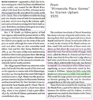
Here's a description from a venerable book called Minnesota Place Names by Warren Upham. (The blue outline is just a bonus fact for your next Incredibly Trivial Persuits game). The pink outlines talk about Peace Rock, and the green underline made me laugh.
Peace Rock is visible from the River Road, but it's pretty well shrouded in trees.
Another vanished feature of the area was a dance hall/bar called Mississippi Lodge, which was built about where Watab Siding is marked on the 1914 map. It was gradually replaced by a supper club called Pirate's Cove. The Cove burned down in the fall of 1998. There've been a number of different schemes to redevelop the restaurant and area, but with little success so far.
But hey, whatever happens there, someday, it'll be HISTORY, right?


I was enthralled by the timeline of the Red River trail onwards past your old house. Wow, that is cool. I remember the petroglyphs on the rock but never knew their significance. Good sleuthing, Larry and Birdus.
ReplyDeleteWhere is the history of the peace rock. They. Banned it. It was a place for the Indians woman and children and old to go and not get slotered
ReplyDeleteI love the concept of Peace Rock, and am upset that nobody in Sterns country has really done anything about making this place stand out. I remember going up the Miss River a few years back when we had a cabin on the point at Little Rock Lake and after I went there, I was surprised to find it is almost covered with brush and looks like it will soon be destroyed for housing. I wrote a novel called Wild Rice Moon and used Peace Rock as the home of one of my Native American characters named Gray-Hawk, who supposely was born half Sioux and half Ojibwe. It was just such a cool idea. The area right off the highway when you turn into the road going to Little Rock Lake, had a number of Indian camps. The road going to the point has an indian burial ground on private property and I believe there are many Indian burial grounds in that area. In 2025, we all need a "Peace Rock!"
ReplyDeleteThe St Cloud, Sartell and Sauk Rapids area has so much history and little of it seems to be known. Now that the paper has diminished in readership, we no longer get any articles on history of the area. I miss this.
ReplyDelete